Midstate By Rail
I've spent countless hours poring over maps of hiking trails and thinking about doing them. But if there's one thing I dislike more than I like hiking, it's cars. Unfortunately, us Americans have apparently decided that outdoor recreation should only be accessible to those with access to cars. That means most of the time when I want to go hiking, I have to be annoyed at car culture for several hours on the drive to the trailhead. If I want to go backpacking, I have to be annoyed that I need to leave a rental car sitting at the trailhead for several days, racking up daily charges for zero miles of driving. And doing a point to point hike leads to yet more challenges. But what if there was another way?
One day, I lined up maps of the Boston commuter rail network and the map of long distance trails in Massachusetts, and was surprised to find that there was overlap! The Midstate Trail is a long distance hiking trail slicing North and South across the entire state, and conveniently passes right near the ends of two different commuter rail lines, by Worcester and Wachusett/Fitchburg. The section of trail between these stations is roughly 40 miles long, and goes up Mt Wachusett. Given its mostly flat topography besides the Mt Wachusett segment, I decided to try to do it as a "fastpacking" trip, meaning that I'd carry all my camping gear in a running style vest/backpack, and run as many of the miles as I could.
Getting to/from the Trail
In my opinion, the better direction to do this trail is south to north. The reason is that there is a bus from Worcester that can take you to the trailhead, but I have no idea whether it would actually stop for you if you were trying to get picked up. Also, I don't want to be dealing with bus and train transfers late in the day. If you finish at Wachusett station, you can just get on the commuter rail and go directly back into Boston.
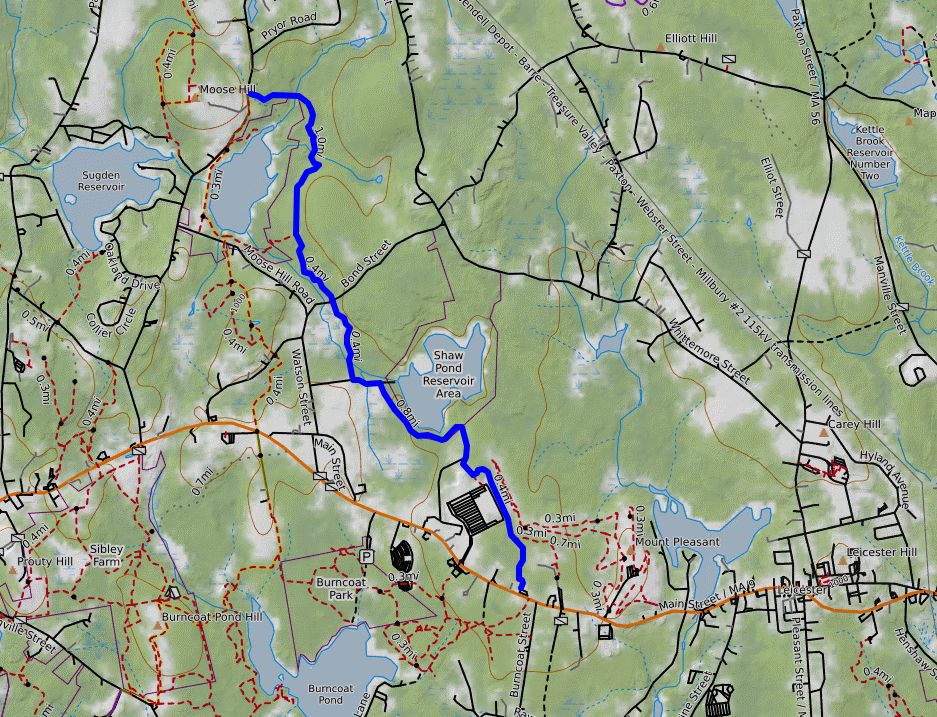
Getting to Worcester is easy: take the Worcester commuter rail from Boston. From Worcester, you can take the 33 bus from the Worcester train/bus station directly to the trailhead along Main St. I made the mistake of getting off too early because OpenStreetMaps told me there were trails from the Cumberland Farms gas station all the way to the Midstate. These trails do not exist, I spent 20 minutes bushwacking and hoping they would suddenly appear before needing to crawl back out of the woods behind the gas station and then do a 1.3 mile road walk. Just get off at the intersection with Polar Springs Rd and save yourself the hassle. Below is a map of where NOT to go. The trails below DO NOT EXIST.
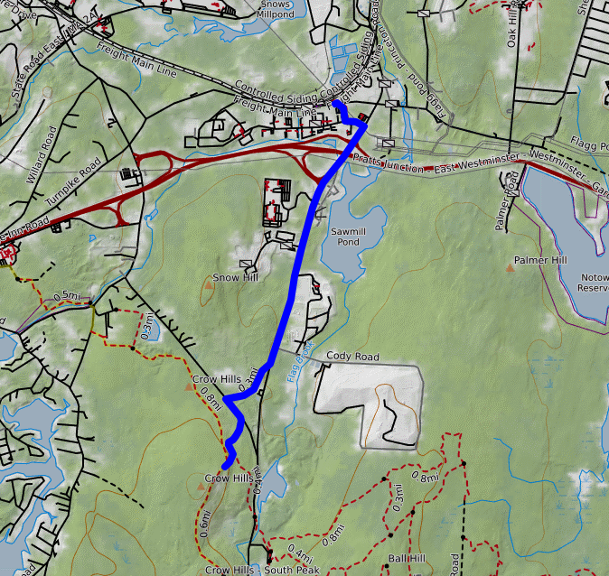
Getting back from Wachusett is slightly annoying because of the road walk, but after getting to the station you can just take the train straight back to Boston. Below is the road walk I took. It is a very busy highway, so it was unpleasant. It might be possible to keep walking along the Midstate until Waterman Lane and then take Turnpike Road instead. These roads seem less busy but add an extra mile or two to your trip.
Camping
I did this trail in 2 days and 1 night, and stayed the night at Long Pond shelter. This a lean-to approximately 10 miles from the Worcester trailhead and 30 miles from the Wachusett station. I had no problems sleeping here, but it does mean the mileage on the second day is quite high. I have heard there may be a campsite another few miles north of Long Pond and maybe a mile off trail, but I do not know any details about it and it is not an official Midstate Trail shelter.
My Experience
The first day was very flat and through peoples' backyards, old logging roads, and other degraded or not very wild settings. Be prepared for a realistic portrait at how Massachusetts undeveloped lands tend to look like, but don't expect pristine wilderness.
The second day, my knee started to hurt and I could not run, so the 30 miles ended up being very long as a hike. The trail passed through a few places that are more wild and remote, though it also continues to provide logging roads complete with clearcuts, people's yards, and short roadwalks. The area near Mt Wachusett and Crow Ledges was the highlight for me as there were some nice views.
I left the trip feeling glad I'd done it, and I would recommend that others try it if they live in Boston and want to see what the undeveloped lands in Massachusetts look like. I don't think I would do the rest of the Midstate trail, though, and think there are better options for trails of its length and difficulty if one is willing to use a car.